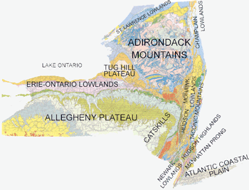
| ALLEGHENY PLATEAU |
|
Geology
|
Geomorphology |
A tour of glacial features near Tully, NY and southern Cayuga Lake. Includes classroom activities.
|
|
|
Letchworth State Park |
A tour of the geology and geomorphology of the park and its waterfalls.
|
|
|
Ithaca Gorges |
A comprehnsive tour of Enfield Glen, Taughannock Falls, Ludlowville Falls, as well as Cascadilla and Fall creeks on the Cornell Campus. Includes several classroom activities and questions to provoke class discussion. (Lots of pictures and maps....big file)
|
|
|
Schoharie Creek |
A tour of the entire creek from mouth to source.
|
|
|
St. Lawrence
Chesapeake
Divide |
The Valley Heads Moraine forms the height of land that is the divide between runoff that drains northward into Lake Ontario and southward into the Chesapeake drainage system.
|
|
|
Rome Sand Plains |
The mosaic of habitats created by the unique geology of these sandy remnants of the Ice Age make the Sand Plains a rich ecological, as well as geologic, resource.
|
|
Environment
|
2006 Flooding |
June 2006 Flooding in the Allegheny Plateau near Port Jervis and Livingston Manor.
|
|
|
NYC Water Supply
|
A turn of the faucet in any New York City location marks the end of the voyage for fresh water that has traveled almost 100 miles through a system of reservoirs and underground conduits to supply NYC with 1.3 billion gallons of water daily. An entire lab activity accompanies this tour. Stops along the way include the Ashokan Reservoir, the Hudson River crossing near Bannerman's Island, and the Kensico Reservoir. |
| DOWNLOAD THE ALLEGHENY PLATEAU TOURS INDIVIDUALLY BY CLICKING THE LINKS ABOVE. |
| CHAMPLAIN LOWLANDS |
|
|
Geology
|
The Ausable River |
The Ausable River has cut a dramatic gorge through the Potsdam Sandstone it crosses on its way to Lake Champlain. Sediments deposited at the mouth of the Ausable have produced a broad delta and a nice, sandy beach.
|
|
|
Champlain Thrust Fault |
A low angle thrust fault formed as the proto Atlantic Ocean closed during the Taconic Orogeny. It is visible today on the eastern shores of Lake Champlain. This stop includes a brief classroom activity.
|
|
|
Champ! |
Lake Champlain has its own Loch Ness Monster. Is Champ real? Includes a classroom activity and discussion questions.
|
|
|
Charlotte the Whale |
In the distant past, whales actually lived in the Champlain Sea, when it was connected directly to the ocean. Learn about the discovery of this fossil whale, and the science that unraveled the mystery of her appearance in the sediments of a freshwater lake.
|
| GET THE ENTIRE CHAMPLAIN LOWLANDS TOUR HERE. |
| ERIE ONTARIO LOWLANDS |
Geology
and
Environment
|
The E-O Lowlands |
This comprehensive tour includes glacial history, Niagara Falls, the Niagara Escarpment, current and former spillways, the locks at Lockport, and various glacial features. This is a big (4.5 Meg) file.....
|
|
|
Canandaigua Lake |
Learn about the glacial history of Canandaigua Lake, one of NY's Finger Lakes. While the Finger Lakes are part of the Allegheny Plateau, the north end of the lakes abut the Erie Ontario Lowlands, and the lakes discharge into the Lowlands.
|
|
|
Cascade Mill
Exercise |
This tour includes an in depth lab activity wherein students analyze maps, images, and information to perform an environmental assessment of the development of an old mill.
|
| GET THE ENTIRE ERIE ONTARIO LOWLANDS TOUR HERE. |
| HUDSON HIGHLANDS |
|
Geology |
Glaciology at Bear Mt. |
During the last ice age, glaciers covered Bear Mt., scouring and sculpting the hard rock of its summit.
|
|
|
Views of the Highlands
|
The Highlands are developed on old, resistant metamorphic rocks, and offer many scenic views of the Hudson River.
|
|
|
Schunnemunk Mt.
|
At the very northern end of the Hudson Highlands, Schunnemunk sits atop the Taconic Unconformity - a late Devonian outcrop of purple 'puddingstone' conglomerate rock. |
|
|
Structural Geology
|
The Highlands are bounded on the south by the Ramapo Fault. See a geologic map overlay of the Highlands here.
|
Environment
|
Lizards and Skinks! |
The Highlands are home to a few reptiles at the very northern end of their ranges.
|
|
|
NYC Water Supply
|
A turn of the faucet in any New York City location marks the end of the voyage for fresh water that has traveled almost 100 miles through a system of reservoirs and underground conduits to supply NYC with 1.3 billion gallons of water daily. An entire lab activity accompanies this tour. Stops along the way include the Ashokan Reservoir, the Hudson River crossing near Bannerman's Island, and the Kensico Reservoir. |
|
|
The Great Swamp |
Pics and info on one of the largest freshwater wetlands in NY, and a major source of natural filtration for the Croton Reservoir. The Great Swamp is also a major flyway for migratory birds, and is home to a variety of rare species of plants and animals. Virtual Field trip description, along with instructions for running a field trip to the Great Swamp are included here.
|
| GET THE ENTIRE HUDSON HIGHLANDS TOUR HERE. |
| MANHATTAN PRONG |
|
Geology
|
Central Park |
View metamorphic rock, glacial features, differential weathering, and Cleopatra's Needle.
|
|
|
Pound Ridge Reservation |
Topo and trail map for a virtual (or actual) fieldtrip for Regents Earth Science. Stops include bedrock, float, mass wasting, jointing, glacial polish, and more.
(Pound Ridge Reservation in Cross River, NY)
|
|
|
Katonah, NY |
Observe a metamorphic outcrop of Fordham Gneiss along Route 35.
|
|
|
Convergent Boundary Features |
View the Staten Island serpentine belt formed during the island arc collision of the Taconic orogeny
|
|
Environment
|
Mianus River Gorge |
Part of the Long Island Sound watershed, the river flows through a glacially-carved valley, previously dammed by glacial deposits (moraine). Interestingly, the river crosses the Cameron's Line fault. This fault marks the boundary between proto-North America and the terranes tacked on during numerous orogenies (see NE-SW valley south of placemark).
|
|
|
NYC Water Supply
|
A turn of the faucet in any New York City location marks the end of the voyage for fresh water that has traveled almost 100 miles through a system of reservoirs and underground conduits to supply NYC with 1.3 billion gallons of water daily. An entire lab activity accompanies this tour. Stops along the way include the Ashokan Reservoir, the Hudson River crossing near Bannerman's Island, and the Kensico Reservoir. |
| GET THE ENTIRE MANHATTAN PRONG TOUR HERE. |
| TACONIC MOUNTAINS |
|
Geology
|
The Taconic Orogeny |
The Taconic Orogeny had a great effect on the geologic structure of basement rocks in the New England area. For more information about the Highlands Province and associated Taconic Orogeny click on the following link. Taconic Geology.
Acknowledgments
.
|
|
|
Walloomsac Fm |
Photo stop along Rt. 55 of biotite-rich schists and tight isoclinal folds of the Walloomsac Fm.
|
|
|
Taconic Unconformity |
Photo stop of the Taconic unconformity at the intersection of Rts. 23 and 9; south end of Becraft Mtn. The Silurian Rondout Fm rests with angular unconformity on cherts of the Mt Merino Fm. Bedding thrusts occur within the Roundout Fm and overlying Manlius Fm.
|
|
|
Briarcliff Dolostone |
Photo stop along Rt. 55 of metamorphosed Briarcliff Dolostone containing light colored dolostone with yellow, white and black chert layers.
|
|
|
Everett Phylite |
Photo stop of a trail hike to Bash Bish Falls at Taconic State park. A metamorphic lithologic transition from slate to phyllite. At the trailhead, the rocks are greenish slates and phyllites rich in chlorite mica. Near the falls, the rocks are higher grade metamorphics with garnet and staurolite in positive relief due to differential weathering. At the falls, the bedrock surface is channelized due to stream abrasion.
|
|
|
Bennington Vt Bypass |
Photo stop along Rt 279 of an incredible view of dramatically folded calcareous rocks.
|
|
|
Stark's Knob |
These "Pillow Lavas" formed as Ordovician basalts erupted under the waters of a shallow sea that covered NE NY during that time period.
|
| GET THE ENTIRE TACONIC MOUNTAIN TOUR HERE. |